Satellite history at UW-Madison comes full circle with award
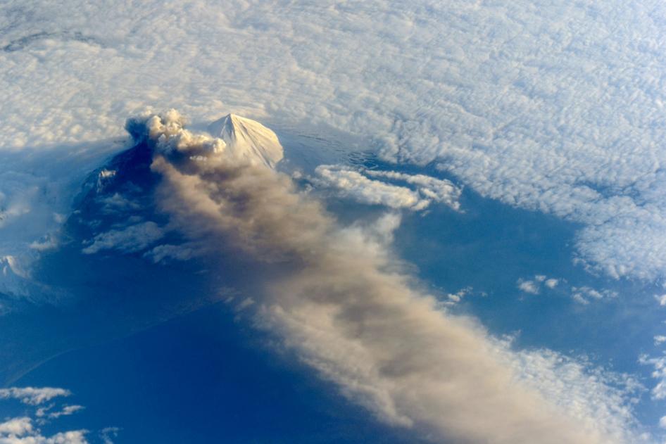
Astronauts aboard the International Space Station photographed this view of Pavlof Volcano in the Aleutian Arc of Alaska on May 18, 2013. The volcano jetted lava into the air and spewed an ash cloud 20,000 feet high.
Photo: NASA
Michael Pavolonis thinks of himself as a volcano guy.
As a physical scientist with the National Oceanic and Atmospheric Administration (NOAA), based at the University of Wisconsin–Madison Cooperative Institute for Meteorological Satellite Studies (CIMSS), Pavolonis developed a satellite-based system to detect volcanic eruptions across the world. It enables more timely and accurate volcanic ash cloud advisories and is now used by NOAA Volcanic Ash Advisory Centers in Washington D.C. and Alaska.
“Volcanic Ash Advisory Centers are the front line of action in warning about volcanic-cloud hazards, and Mike’s quantitative retrievals, corresponding training materials, and visits are in high demand,” writes Marianne Guffanti, a U.S. Geological Survey volcanic ash expert, in a letter nominating Pavolonis for the 2015 NOAA David Johnson Award.
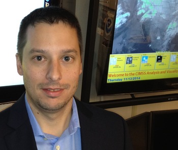
Michael Pavolonis
Pavolonis was chosen this month for the honor, sponsored by the nonprofit National Space Club and awarded in memory of the late Johnson, first assistant administrator of NOAA’s Satellite and Information Service (NESDIS).
Each year, the award is presented to a young professional in recognition of outstanding, innovative uses of Earth-observation satellite data for operations in order to predict atmospheric, oceanic or terrestrial conditions.
Earlier this year, Pavolonis briefed the U.S. House and Senate as well as NOAA senior leadership on the importance of satellites in mitigating volcanic hazards. He also runs the NOAA/CIMSS volcano imagery site and his volcanic eruption system has proved helpful for researchers around the world.
In addition to his volcano work, Pavolonis is leading the development of ProbSevere, a new weather prediction model that determines the likelihood that storms will produce severe events like thunderstorms or tornados within a 60 minute window.
When the NOAA/CIMSS team demonstrated ProbSevere at NOAA’s Hazardous Weather Testbed this summer, the model added at least 10 minutes of lead time to severe weather warnings over half of the time.
Pavolonis developed a satellite-based system to detect volcanic eruptions across the world. It enables more timely and accurate volcanic ash cloud advisories.
“This product truly represents the future of forecast and warning products,” Jeffrey Craven, science and operations officer for the Milwaukee/Sullivan National Weather Service Forecast Office, writes in Pavolonis’ nomination letter.
Pavolonis got his start at UW–Madison, earning both his master’s and doctoral degrees in atmospheric and oceanic sciences. He hasn’t strayed far and his award, too, has UW–Madison ties.
In 1966, the late UW–Madison professor and Space Science and Engineering Center founder Verner Suomi — considered the father of satellite meteorology — collaborated with Johnson and NASA to launch the first spin-scan cloud camera into Earth’s orbit. Suomi’s camera enabled weather satellites to gather continuous images of weather as it happened, much like the weather loops seen today.
In 1977, Johnson teamed with Suomi once more, sending nine of his best people to Madison, bridging the gap between the operations of NOAA and the research at the university, and founding what would become CIMSS a few years later. The NOAA Cooperative Institutes program would evolve from these first arrangements with UW–Madison and other institutions.
—Sarah Witman
Tags: climate change, research, space & astronomy, weather
-
UW–Madison’s reach throughout Wisconsin adds up to $38.9 billion a year
The university supports more than 287,000 jobs and helps drive private-sector growth.
-
‘Being part of something bigger than you’ with Badger Volunteers
UW–Madison students head into the local community to find purpose and make a difference.
-
UW–Madison again named a ‘new Ivy’ by Forbes
The university was selected as one of the best in the country at "preparing and graduating the talent" that meets today's workforce needs.
-
UW–Madison graduate programs ranked among the nation’s best by U.S. News
Nearly 20 programs ranked in their respective Top 10 lists, shining a light on the breadth and depth of the university’s graduate offerings.