App makes smartphone users ‘king or queen’ of weather satellites
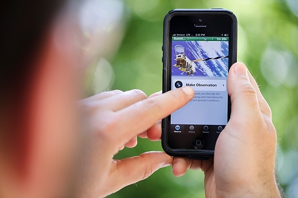
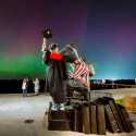
A man uses a SatCam application on his smartphone to make and submit an observation of cloud conditions for comparison with images collected simultaneously by weather satellites.
Not long ago, Liam Gumley found himself in a meeting sitting between frustration and inspiration.
“On one side of me is this guy from a joint satellite program saying, ‘I wish there was a way we could get the public involved in this project,’” says Gumley, a satellite researcher in the University of Wisconsin–Madison’s Space Science and Engineering Center (SSEC). “Same meeting, on the other side of me sits another guy who’s talking about the smartphone app he made for home-brewing beer.”
Tasked with assessing and improving the data from instruments about the Suomi NPP satellite (named for UW–Madison satellite meteorology pioneer Verner Suomi) before and after its launch in October 2011, Gumley was struck by the power of a huge network of Earth-bound instruments.
“Smartphones have cameras, they have GPS, they have Internet connections,” he says. “Let’s put those to work.”
Using the SatCam app developed by Gumley, Dave Parker and a team of SSEC researchers, any iPhone user in the world can help sharpen the “cloud mask” applied to data collected from three satellites — Suomi NPP, and NASA’s Terra and Aqua — collecting data on Earth’s weather and climate.
Computer algorithms process data from the three satellites, producing an ocean of information (or a mountain in Terra’s case) about conditions on the planet’s surface and in its atmosphere.
“We tried to make it so a scientist could use it or a kid in 6th grade could use it. It had to be easy and intuitive; no pressure that you would do it wrong somehow.”
Liam Gumley
“Satellite data can tell you about snow cover, urban expansion, sea surface temperature or phytoplankton load — which is a measurement of the productivity of a part of the ocean, and can tell you things like whether the fishing should be good,” Gumley says.
But if you want to know the sea surface temperature, you need to be confident you’re looking at the sea surface. Occasionally, stuff gets in the way.
“We have to take an image from the satellite and look at each pixel and say this one is a cloud, this one isn’t, this one might be a cloud,” Gumley says.
While it may be easy to tell the difference between the green canopy of a forest and a thunderhead, discerning between a snow-covered college quad and fluffy white clouds is another matter — one well suited for human eyes.
SatCam knows when one of the three satellites, which complete a trip around the Earth from pole to pole in north-to-south, south-to-north loops every 100 minutes, will pass overhead. The app prompts users to take a picture of the sky directly above them, and another of the horizon to give researchers a peek at the surrounding terrain.
“We tried to make it so a scientist could use it or a kid in 6th grade could use it. It had to be easy and intuitive; no pressure that you would do it wrong somehow,” Gumley says. “And we wanted to give people a reward for helping — something interesting and unique, but not expensive. So, we send you back the picture the satellite took of you.”
“You get to feel like king or queen of that satellite, almost like it’s doing your bidding through your smartphone.”
Liam Gumley
That is, a picture of the wider part of the world where the user was standing. As colorful and detailed as they are, the satellites can’t pick up a single iPhone user staring up at the sky.
But users have now submitted 4,600 observations of cloud cover (or lack thereof) and received photos of their own relative neighborhoods on five different continents.
“The app leverages a big stack of infrastructure starting here at the Space Science and Engineering Center in Madison and going all the way up to the very expensive satellites in orbit,” Gumley says. “You get to feel like king or queen of that satellite, almost like it’s doing your bidding through your smartphone.”
The SSEC team is at work on a website compiling the thousands of photos, and may follow the iPhone app with a similar tool for citizen scientists carrying Android phones.
Tags: climate change, technology, weather
-
UW–Madison again named a ‘new Ivy’ by Forbes
The university was selected as one of the best in the country at "preparing and graduating the talent" that meets today's workforce needs.
-
UW–Madison graduate programs ranked among the nation’s best by U.S. News
Nearly 20 programs ranked in their respective Top 10 lists, shining a light on the breadth and depth of the university’s graduate offerings.
-
UW–Madison students ‘step into the professional world with a purpose’
More than 90% of UW graduates say their education prepared them for their career, according to new survey results.
-
How UW–Madison and industry are working together to shape Wisconsin’s AI future
As businesses explore how to apply AI effectively and responsibly, UW researchers, faculty and students are offering their knowledge in the emerging space.