
Global winds could explain record rains, tornadoes
Two talks at a scientific conference this week will propose a common root for an enormous deluge in western Tennessee in May 2010, and a historic outbreak of tornadoes centered on Alabama in April 2011.
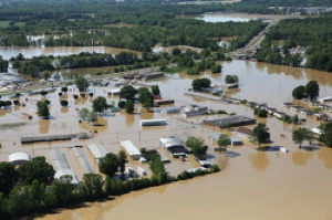
An aerial view shows severe flooding that hit Tennessee in 2010.
Both events seem to be linked to a relatively rare coupling between the polar and the subtropical jet streams, says Jonathan Martin, a University of Wisconsin–Madison professor of atmospheric and oceanic sciences.
But the fascinating part is that the change originates in the western Pacific, about 9,000 miles away from the intense storms in the U.S. midsection, Martin says.
The mechanism that causes the storms originates during spring or fall when organized complexes of tropical thunderstorms over Indonesia push the subtropical jet stream north, causing it to merge with the polar jet stream.
The subtropical jet stream is a high-altitude band of wind that is normally located around 30 degrees north latitude. The polar jet stream is normally hundreds of miles to the north.
Martin calls the resulting band of wind a “superjet.”
Jet streams in the northern hemisphere blow from the west at roughly 140 miles per hour, and are surrounded by a circular whirlwind that looks something like a tornado pushed on its side. The circulating wind at the bottom of the jet stream blows from the south. On the north side, the circulating winds turn vertical, lifting and cooling the air until the water vapor condenses and feeds precipitation.
A superjet and its circulating winds carry roughly twice as much energy as a typical jet stream, Martin says. “When these usually separate jet streams sit atop one another, there tends to be a very strong vertical circulation, which produces clouds, precipitation and tornadoes under the right conditions.”
And because the circulating wind in a superjet moving across the U.S. south picks up moisture from the Gulf of Mexico, “the superjet gives a double-whammy – more moisture, and more lifting, producing that intense rain.”
That was the case in May 2010, when 10 to 20 inches of rain fell around Nashville.
Andrew Winters, who is now a graduate student studying with Martin, latched onto the Tennessee flood as the topic of his senior undergraduate thesis in 2010. “It had a lot of interesting aspects, brought an anomalous amount of moisture into the southeast, and that hefty amount of rain,” Winters says.
And that super-strong jet stream “could be traced back to conditions in the western Pacific, almost a week earlier,” Winters says.
Martin and Winters describe their work in talks Dec. 6 and 7 at the annual meeting of the American Geophysical Union in San Francisco.
Studies of the Tennessee floods, the Alabama tornados, and an odd October storm in Wisconsin showed “that when the subtropical jet is pushed poleward under the influence of strong thunderstorms in the western Pacific, it seems to result in these intense storms in the U.S. midsection,” Martin says. “It’s a really fascinating global connection that occurs seven to 10 days later.”
Martin also suggests the altered position of the subtropical jet stream may be linked to global warming.
“There is reason to believe that in a warmer climate, this kind of overlapping of the jet streams that can lead to high-impact weather may be more frequent,” Martin says.
That idea can be tested, Martin adds.
“Historic weather data should tell us whether there has been a change in the frequency of these overlapping events, and whether that might be linked to a change in high impact-weather events. It’s an interesting lead that could help us understand one possible mechanism by which a warmer climate could lead to an increase in severe weather,” he says.
Although hurricanes can be tracked for a week or more as they cross the Atlantic Ocean, weather phenomena seldom last so long, Martin says. “If the subtropical jet stream is rearranged and superposed on top of the polar jet stream, it might be the mechanism that allows for this very long delay, a disturbance that can have discernible effect on severe weather thousands of miles downstream, and a week or more later.”
Martin says that if the new analysis survives further study, it could contribute to severe weather forecasting.
Though severe weather was forecast a day or two in advance of the deadly tornado outbreak in the Southeast this April, “most tornado forecasts are made 12 or at most 24 hours in advance. That saves lives. But if we get the idea five or six days in advance that we should watch the position of the jet streams, we could say, ‘Hey, we have a pretty exciting week coming up, we have to be on high alert.’”
-
Interwoven
How Indigenous knowledge and science can work together to communicate about climate.
-
UW–Madison’s reach throughout Wisconsin adds up to $38.9 billion a year
The university supports more than 287,000 jobs and helps drive private-sector growth.
-
‘Being part of something bigger than you’ with Badger Volunteers
UW–Madison students head into the local community to find purpose and make a difference.
-
UW–Madison’s Tech Exploration Lab: Where the classroom meets the real world
The lab is built around a simple expectation: Students come to build, test and refine projects with real problems in mind.


