
Art from above: Satellites see Wisconsin
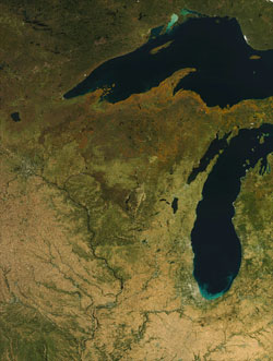
Wisconsin in autumn, October 7, 2010. In this true color image from NASA’s Aqua satellite it is possible to see the orange colors of the changing foliage in northern Wisconsin and sediments in the southern waters of Lake Michigan, stirred by wind.
Image: Liam Gumley, UW–Madison Space Science and Engineering Center
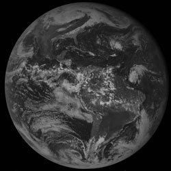
This view of the Western Hemisphere, taken Oct. 27, 2010, captures the large mid-latitude storm that, as it intensified over the Great Lakes, set a record low pressure for the continental United States at Superior, Wis. The system generated two days of extremely high winds gusting to 50-60 miles per hour.
Image: Tim Schmit, Gary Wade, NOAA Advanced Satellite Products Branch
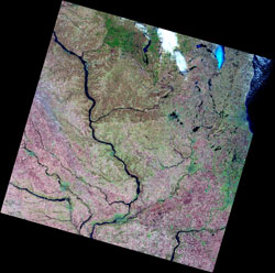
Taken by the Indian Resources Satellite (IRS) satellite on March 26, 2010, this picture of Wisconsin shows the Mississippi and Wisconsin Rivers and, in the upper right, ice on Lake Winnebago.
Image: Peter Wolter, UW–Madison Department of Forest and Wildlife Ecology; Sam Batzli, UW–Madison Space Science and Engineering Center

A satellite view of Madison, Wis. Taken by the commercial satellite IKONOS, which can take pictures from space comparable to airborne photos taken from fixed wing aircraft. The image here, which blends 4-meter resolution color imagery with 1-meter resolution black and white imagery, is similar to what is now used by Google Earth and Google Maps.
Image: Sam Batzli, UW–Madison Space Science and Engineering Center
Few know that the genesis of observing the Earth’s weather from space is a Wisconsin idea.
The late Verner Suomi, the atmospheric scientist and professor who founded the University of Wisconsin–Madison’s Space Science and Engineering Center in the 1960s, is considered by many in the know to be the father of weather satellite meteorology. He, along with Wisconsin engineer Robert Parent, invented the technologies that made it possible to take continuous pictures of our planet from a satellite positioned in geosynchronous orbit. Suomi also devised a system to process, manipulate and display those images for the benefit of forecasters and anyone who has ever watched the weather on television or the Internet.
Those pictures from space have practical value, certainly, as we plan our days and decide what to wear and can be lifesavers when severe weather looms. But woven into the pixels of the innumerable images satellites of all kinds constantly transmit is the natural beauty of our planet as viewed from space.
Now, dozens of artful satellite pictures of Wisconsin and neighboring regions will be on prominent display for anyone transiting the Dane County Regional Airport in an exhibit, Satellites See Wisconsin, to run from Feb. 4 to Sept. 9. The exhibit, organized by UW–Madison’s Tandem Press in conjunction with a 15-member team from the UW–Madison Space Science and Engineering Center, will feature themes of weather, the seasons, landscapes and water, all with a focus on the Badger State.
“The goals of the exhibit are to, one, inform folks of the current and historic role UW–Madison plays in satellite remote sensing and, two, to show how satellites are used to study Wisconsin’s environment,” explains exhibit organizer and atmospheric and oceanic sciences professor Steve Ackerman.
Among the three dozen images on display will be pictures depicting seasonal change, massive fog banks over the Great Lakes, ice on Lake Superior and algae blooms in inland lakes.
“The images are visually stunning,” says Paula Panczenko, executive director of Tandem Press. “The most intriguing aspect of the show is that the viewer is drawn to the images visually and then enters into a world of scientific discovery.”
Panczenko, sees the weather satellite art exhibit as emblematic of science returning, in a sense, to a previous age when scientists routinely combined artistic ability with science to illustrate nature: “Prior to the 20th century, many of the greatest scientists did all their own drawings to illustrate their scientific discoveries,” Panczenko explains. “With the new visual technology today we are seeing a return to this and the results are fascinating.”
Also featured in the exhibit is a timeline showing the historical development and use of satellite imagery by Wisconsin scientists, a three-dimensional globe, and a model of Explorer 7, the first weather satellite. In addition, UW–Madison Space Science and Engineering Center staff will install a ‘weather looper,’ a video display of current weather as seen from space.
The exhibit is free and open to the public.
-
Interwoven
How Indigenous knowledge and science can work together to communicate about climate.
-
UW–Madison’s reach throughout Wisconsin adds up to $38.9 billion a year
The university supports more than 287,000 jobs and helps drive private-sector growth.
-
‘Being part of something bigger than you’ with Badger Volunteers
UW–Madison students head into the local community to find purpose and make a difference.
-
UW–Madison’s Tech Exploration Lab: Where the classroom meets the real world
The lab is built around a simple expectation: Students come to build, test and refine projects with real problems in mind.


