
Scientist makes satellite images accessible to all
From locating water sources in Ethiopia to parsing complex processes in the atmosphere over Bulgaria, satellite instruments provide information useful to anyone anywhere. UW–Madison atmospheric scientist Paolo Antonelli has made it his mission to help anyone access and use satellite observations of anywhere in the world.
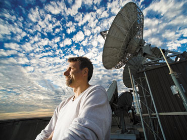
Paolo Antonelli, atmospheric scientist, takes in the view atop the Atmospheric, Oceanic and Space Sciences Building. Antonelli hosts workshops all over the world designed to enable others to take advantage of space-based environmental observing systems.
Photo: Bryce Richter
Originally from Italy, Antonelli was impressed by the wealth of available resources that he could access as a graduate student at UW–Madison.
“Work-wise, this is an unbelievable place,” Antonelli says. Inspired by his experience at UW–Madison, Antonelli set about creating international opportunities to enable others to take advantage of space-based environmental observing systems.
Held in Bologna, Italy, in September 2001, the first workshop lit a spark that has fueled overwhelming international interest. Relying on research institutes, agencies and universities around the world, Antonelli and a small army of colleagues at the Space Science and Engineering Center (SSEC) have pulled together 11 workshops that reached more than 500 participants from around the world.
The structure and content of the workshops essentially stays constant, but the logistical nightmare of coordinating a workshop in a different country has improved significantly since the first workshop. “We don’t lose as much money as in the beginning,” Antonelli says.
The first remote-sensing workshop was a hodgepodge of borrowed space, time and money.
“Everything was difficult,” Antonelli says. “We had enthusiasm so it didn’t seem that bad. It was all done on good will.” The instructors from SSEC paid their own airfare and used vacation time to cover the time away from work. They had five borrowed computers for students to use and a single projector for lectures.
Despite the lack of resources, the students gave the workshop positive reviews. Not only did the participants enjoy the workshop, but they also word spread throughout the remote-sensing community and soon requests for similar opportunities inundated SSEC.
The team tailors each course to meet requirements offered by host and sponsoring organizations as well as potential participants. The overall theme of the content changes from course to course, but participants always go home armed with knowledge, new professional connections and the data processing software to apply their new skills.
For example, a group of SSEC scientists traveled to Brazil in November 2007 to help South American meteorologists and researchers learn how to use the country’s new weather satellite. Formerly a U.S. satellite, the U.S. moved GOES-10 to cover South America when GOES-12 took over for the States. The students left the workshop with an understanding of how to make use of GOES-10 observations as well as the necessary software.
While the sample datasets change and the geographic location varies, the basic schedule remains the same. Each morning, one of the lecturers presents basic concepts of remote sensing. The concepts progress in complexity and are useful for the day’s subsequent lectures and lab work. The second lecture of the day usually focuses on the set of observations that participants will use during the lab session. The lecturer provides details about the instruments used to gather the information as well as insight into the content of the data itself.
During the afternoon, students apply the concepts learned earlier in the day. Using a package of software tools developed at SSEC, the students use satellite observations to assess different aspects of the atmosphere over the host region for the workshop. After a long day, everyone involved in the workshop has opportunities to socialize and to prepare for the next lesson.
For four or five intense days, workshop participants spend several hours a day sponging up information. By the time they head home, these researchers have the knowledge and the tools to use remote-sensing data for a variety of environmental applications. The impact of each seminar spreads as participants return home to pass on what they learned.
The workshops not only provide participants with information and materials but also with a network of international collaborators. After the workshops, participants frequently stay in touch and exchange information and data.
“They form a friendship in a work environment that lasts,” Antonelli says. The resulting network of scientists is one of the main goals of the remote sensing workshops.
Antonelli and his colleagues organize remote sensing seminars on demand, but have had to limit themselves to two each year. However, the need continues to increase and is well beyond what SSEC can handle. However, with unlimited funding, Antonelli would not develop a large-scale effort, but would continue to provide small programs dedicated to a relatively small group of people.
While organizing formal remote-sensing workshops, Antonelli has also started to work with a university in Ethiopia. “There is a tremendous thirst for remote sensing data for localized areas,” Antonelli says. He initially connected with the University of Bahir Dar as he organized a workshop in Benevento, Italy, during 2007. Two participants from the University of Bahir Dar couldn’t make it to Benevento because of logistical challenges, but the professors invited Antonelli to give a condensed version of the course in Ethiopia.
During his time in Ethiopia, Antonelli tailored his lectures, exercises and materials to applications that are practical for Ethiopians. “We need to take the way they live and suggest different ideas,” he says.
However, researchers in Ethiopia have access to very little compared to their European and American counterparts. The university expects to have Internet access in a year or so. For now, Antonelli sends the researchers hard drives loaded with satellite data sets. By practicing with the data provided by Antonelli, the researchers will have the skills to use satellite observations when Ethiopia gains access to such information. Eventually, Antonelli’s Ethiopian colleagues hope to apply what they learn from Antonelli to resource management, disaster response and weather prediction.
After returning from Ethiopia, Antonelli began to explore paths to develop remote sensing facilities at the University of Bahir Dar. By forming a group of researchers able to use the data, Antonelli created a solid basis for funding proposals. He has started negotiations with different institutions in Europe and the U.S.
Antonelli also continues to try to find constant source of support for the formal remote sensing workshops. Currently, he and his SSEC colleagues find sponsors for each workshop as the need arises. Antonelli hopes to make this form of remote-sensing education more sustainable by assembling a permanent program to fund and organize the workshops.
In spite of the lack of consistent support, the workshops continue and the demand grows. Although the workshops vary in theme, location and diversity, all of the workshops share a common element: the participants want more. “It was too short!” one participant wrote. “We want more!”
-
Interwoven
How Indigenous knowledge and science can work together to communicate about climate.
-
UW–Madison’s reach throughout Wisconsin adds up to $38.9 billion a year
The university supports more than 287,000 jobs and helps drive private-sector growth.
-
‘Being part of something bigger than you’ with Badger Volunteers
UW–Madison students head into the local community to find purpose and make a difference.
-
UW–Madison’s Tech Exploration Lab: Where the classroom meets the real world
The lab is built around a simple expectation: Students come to build, test and refine projects with real problems in mind.


